Map Draw - Route tracking and Annotation (Elite)
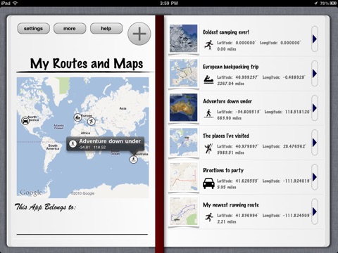
Map Draw allows you to create your own routes and maps on the iPad. Total distance is tracked, and all maps can be drawn on by freehand when exported, making it the ideal tool for planning a run, giving driving directions, keeping track of your travels, and more. Maps support the creation of custom waypoint annotation pins. All map routes and entries are stored in a beautiful journal-style interface on the device. No uploading to or downloading from a website is needed.
Features:
*** Route Drawing****
Use your finger to draw a route on top of the map. Our touch system makes plotting your route easy and accurate, and stores total distance. Routes can be drawn independently of roads, allowing off road trails and hikes to be captured. This is the perfect tool for dynamically mapping a route or run on the iPad.
*** Custom user waypoints****
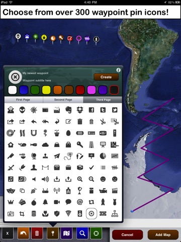
need to add a waypoint or mark a particular location? Weve created an annotation pin system with 300 unique icons in 10 different colors, allowing you over 3000 possible combinations for marking areas of interest on your map or along your route. Customize with icon, pin color, title, and subtitle. Press create, than use your finger to drag and drop to desired location.
*** Freehand drawing and Export *****
All maps and routes you create are stored and saved dynamically on the device, and can be edited and changed at any time. You have the option to export maps as files to be emailed or saved to your photo library. All exported files may be drawn on freehand from within the app, allowing you to add what lines and pins cant say.
Other Features:
- Maps support forward geocoding, allowing you to search for any location by name or address.
- Use the zoom to location feature for easy access to your current location when drawing a route.
- Map type can be toggled between standard, satellite, and hybrid. The type is stored and remembered for each individual map.
- Route Plotting contains undo and clear-all support.
- Each map you create is stored in a journal-style interface for easy access. Every entry is plotted on a graphic map display.
- Journal interface is customizable.
- Application supports both landscape and portrait orientations.
- All Saved routes can be freely edited at any time. Changes are saved automatically.
- Information is cached locally, allowing you to view a route and map offline. However for pinching and zooming, an internet connection is recommended.
- Application contains built-in help and support, is intuitive and easy to use.
Cant think of what routes you might map? Here are just a FEW ideas:
*Create, plan, and store your runs for cardio fitness and training.
*Check the distance between 2 points.
* Map Directions to an event, write any additional notes or info DIRECTLY into the map, then email to your people.
*Track the places you drive. Determine what routes are best.
*Create ALL your evil plans: draw out extraction points, drop off and pickup points, secondary escape plans, and more. Share with evil subordinates, or keep them to yourself.
* Like to travel a lot? Set place marks on all the countries, states, cities, war zones etc, that youve been to.
*Just find a place on the map, and paint to your hearts content: Make the streets look green, scribble out the house of the neighbor you dont like, draw a robot in downtown Tokyo… Whatever you feel like.
*Plan a scavenger hunt or route for someone, plotting the route they would follow, houses they might visit, etc.
* Use to plan your next hiking trip
* Store the routes of all the marathons, 10ks or other races youve done
* Map your biking routes
* Use for Homework in history and geography class. Draw out historical information
* Have another use we didnt cover? Wed love to hear about it!


